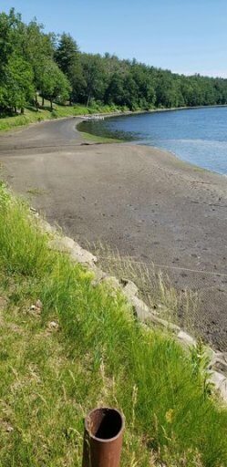
Thanks to everyone who expressed concern about the low water levels in Barton Cove (MA). Between Sunday, June 13 and Monday, June 14, the water levels above the Turners Falls Dam ran low enough to cause alarm. People described fish nests going dry and boaters not being able to come back to shore or launch in the river in Barton Cove.
We dug into what happened and found that by Wednesday, the Federal Energy Regulatory Commission (FERC) wrote a letter to FirstLight saying they had received a complaint and requested FirstLight file a response and an explanation. The response, filed on June 23, left some data unavailable to the public because they contain “sensitive commercial information.”
FirstLight said, in a public statement, they had been dispatched by the regional grid to generate power, and inflow coming from Vernon Dam was “low” for this time of year. FirstLight’s response indicates that the river elevation got as low as 177.5 feet; their license allows them to go as low as 176 feet. A USGS gage on the Connecticut River in Northfield, MA indicates that the river level got down to a gage height that has never been observed in the few years since the Northfield gage was installed (see figure above).
Rivers need water and that’s most apparent when there’s not enough to go around. In FirstLight’s hydro license application, they have requested to keep these same operating limits. CRC will be seeking to answer some of the many questions that this occurrence has raised, and we’ll be requesting that FERC revise the operating range so the river can remain usable for all designated uses year-round.
This update was originally shared in the “CRC News and Events” email news. If you would like to get updates like this delivered to you, sign up to receive CRC e-news. You have the option to subscribe only to lists you select and you can unsubscribe at any time.


