There is flooding somewhere in Vermont every year. When the most recent super flood, Tropical Storm Irene deluged Vermont our infrastructure, roads, culverts and bridges bore much of the brunt of the subsequent flooding. The human species is nothing if not adaptable and we are responding to the potential for future flooding based on what we learned from instructive occurrences that happened during those trying times.
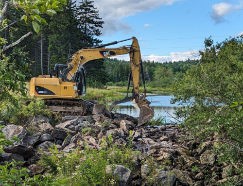
The proper sizing of culverts was one of the key lessons. During high water events, rivers and streams move water, sediment and debris. If a bridge or culvert opening is undersized several bad things happen. The sheer amount of the flow can exceed the ability of the culvert or bridge to move water forming a small reservoir. If the stream then goes around or over the structure, it is usually flowing over erodible materials, soil, sand or even gravel roadbed.
Debris carried in a high flow can block culverts if they are too small to pass it on down the river. Again, the water rises above the height of the structure, a small reservoir forms and again when it overtops or flows around the structure it finds erodible substances.
Whether from high flow levels or trapped debris, once water flanks a structure the water seeks a path through erodible material. Any such cut will become bigger and eventually breach the structure itself releasing not only the high flow but also the reservoir held upstream of the structure. Whoosh, a super charged release of water can take the culvert or bridge out and even when the structure survives, that slug of water moving downstream is looking for ways to make more trouble, high erosion on land and destruction of facilities downstream.
Right sized structures that can accommodate at least 125% of the bank full flow of a stream usually survive high water events. The win win message in this situation is that culverts and bridges that are designed to handle 125% stream flows are large enough so they pass aquatic organisms during normal flows connecting the up and down stream reaches of a stream. This connectivity is key to healthy river life. Most aquatic organisms migrate up and/or downstream during one or more of their life phases. Blockage of fish migration to their upstream spawning habitat is one easily understood impact of undersized culverts.
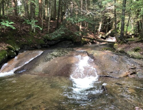
One of the key questions during a storm, the answer to which indicates the potential for damage is how much and how quickly does the overland flow from heavy rain get into the river. With large areas of impervious surface that do not absorb any of the runoff, all the rain not absorbed into the ground quickly runs into the stream. Add together enough parking lots, large buildings and roads in a watershed area and the water levels rise rapidly increasing the erosive power of a stream. Undisturbed riparian buffers slow down the runoff giving the ground a chance to absorb some of the rainfall lowering the rise in water level. The win win lesson here is that a healthy riparian zone adds woody debris (food) to a stream, allows for the use of riparian zone by wildlife and provides shade meaning higher dissolved oxygen levels in the water by keeping the water temperature lower.
We know that there will be floods. Given that reality, it would be reasonable to ask, are there choices that we can make that will attenuate floodwaters in the future? The answer is yes and the experiences of Rutland and Middlebury is a prime case in point. Rutland and Middlebury sit on the banks of Otter Creek. Their experience is enlightening when you compare what happened during TS Irene in Rutland when the Otter Creek flooded and then in Middlebury 30 miles downriver. Otter Creek flooded Rutland with river flows of almost 19,000 cubic feet per second (CFS) on August 28, 2011 which is the highest flow ever recorded for the river in Rutland. Even with added flow from tributaries to Otter Creek between Rutland and Middlebury, the flow in Middlebury peaked four days later at only 7,000 CFS with little flooding or damage.
The answer to why the rush of floodwater slowed down with a lower crest in just 30 miles was the intact floodplain between the cities. The land between them is broad, flat, has extensive wetlands and is for the most part undeveloped. The floodwaters spilled onto the floodplain as nature intended. As the river level fell, the floodplain gradually released the floodwater back into the river to then flow safely past Middlebury.
The win win nugget here is that intact floodplain is a flood release valve but also that the open land welcomes wildlife in the wetland areas and agriculture on the rest of the land. The Nature Conservancy with help from the USDA Natural Resources Conservation Service along with local groups have conserved the land so the floodplain protections will be in place forever.
You might look at the web site floodready.vermont.gov. There you will find features about flood resilience including how to use natural flood protection, improve infrastructure and ways to fund improvements. We know what to do to minimize the impacts of flooding. Let’s just do it!
David L. Deen is Upper Valley River Steward for the Connecticut River Watershed Council. CRC is celebrating over 60 years as a protector of the Connecticut River.